


Files
Download Full Text (2.1 MB)
Description
Mary Valle, GES 460/529: Environmental Field Methods and Analysis
Faculty Mentor: Professor Elisa Bergslien, Earth Science and Science Education
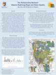
Water quality data is available for several different bodies of water across Western New York. For this project, the data that is publicly available over the internet will be complied to provide a general overview of the state of local bodies of water, particularly with respect to chemicals that are harmful to human health and ecosystems. Some of the chemicals of particular concern are Aluminum, Ammonia, Arsenic, Barium, Cadmium, Chloramine, Chromium, Copper, Fluoride, Lead, Nitrates, and Mercury. These chemicals have been proven to cause acute and chronic effects on the human body. Acute effects are effects that occur within hours or days after a person is exposed. Chronic effects occur after continuous exposure to these contaminants over the course of many years. Information on all of these contaminants may not be in available for every body of water, which is also useful information as it will show where there are gaps in our knowledge. The available data will be complied graphically and then this information will be compared, wherever possible, to the historic Redlining Maps created by agents of the federal government's Home Owners' Loan Corporation between 1935 and 1940 in order to determine if there is a relationship between water quality and the classification of the surrounding neighborhoods, with the prediction that the most contaminated bodies of water will be associated with a lower assigned neighborhood ‘quality’ grade.
Publication Date
2020
Recommended Citation
Valle, Mary, "The Relationship Between Historic Redlining Maps and Water Quality" (2020). Physical Geography and Sciences. 22nd Annual Student Research and Creativity Conference. SUNY Buffalo State.
https://digitalcommons.buffalostate.edu/srcc-sp20-physgeosci/26