


Files
Download Full Text (634 KB)
Description
Cecilia Pershyn, GES 529: Environmental Field Methods and Analysis
Faculty Mentor: Professor Elisa Bergslien, Earth Sciences and Science Education
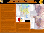
Buffalo built its economy by being an industrial powerhouse throughout the second half of the 19th century. In its heyday, Buffalo was home to a booming shipping industry, grain mills, steel & iron plants, and numerous other factories. Businesses & manufacturers were drawn to Buffalo for its prime location at the end of the Erie Canal and on the Great Lakes. Although Buffalo has seen a decline in manufacturing over the decades, many industries, especially those whose manufacturing processes are water-intensive, continue to operate in Buffalo. Many of these facilities pose an environmental threat by releasing toxic chemicals into the air or water surrounding their sites. The communities in close proximity to these facilities are at risk of exposure to environmental contaminants. According to historic redlining maps, most residential areas surrounding industrial zones were characterized as “definitely declining” or “hazardous” as they were made up of working-class, non-white or foreign-born individuals and families. A spatial analysis of toxic release sites in Buffalo will be conducted to determine which geographic areas of the city are most at risk for exposure from contaminants released from these sites. Data from 2010 census zip codes will be used to conduct an inquiry of socioeconomic characteristics in at-risk neighborhoods. Educational attainment, annual income, homeownership and race will be used to determine which demographic is most at risk for exposure from toxic substances releases as reported in the TRI. At-risk neighborhoods will be compared to the historical 1937 redlining maps of Buffalo to determine if these areas predominantly fall in “hazardous” or “definitely declining” characterized neighborhoods. Finally, the 2010 census data from at-risk neighborhoods will be compared to socioeconomic characteristics from the 1937 redlining maps to determine how the demographics of these neighborhoods have changed over time, with the prediction that neighborhoods that were deemed “hazardous” or “definitely declining” in the redlining maps are the ones still at risk for toxic substance exposure in contemporary times, and that the socioeconomic characteristics have not significantly changed over time. The importance of this study is to determine how historically disadvantaged neighborhoods may still be at risk for exposure to environmental contaminants, which has environmental justice implications that should be considered as Buffalo undergoes its economic resurgence.
Publication Date
2020
Recommended Citation
Pershyn, Cecilia, "A Spatial Analysis of Toxic Release Sites in Buffalo, NY and Socioeconomic Characteristics of Surrounding Neighborhoods" (2020). Physical Geography and Sciences. 22nd Annual Student Research and Creativity Conference. SUNY Buffalo State.
https://digitalcommons.buffalostate.edu/srcc-sp20-physgeosci/17