

Files
Download Full Text (7.2 MB)
Description
Skyler Paternostro, Earth Sciences
Faculty Mentor: Professor Jill Singer, Earth Sciences and Science Education
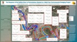
The Buffalo River discharges into Lake Erie near the upper end of the Niagara River. The lower 9.2 km of the river has been designated as a Great Lakes Areas of Concern (AoC) because of a number of environmental impairments including contaminated sediments. As the river undergoes remediation in order to be delisted as an AoC, a management decision was made to remove the most contaminated sediment in an environmental dredging project that took place between 2011 and 2015. To verify the volume of sediment removed from each dredge cell, the United States Army Corps of Engineers (USACE) annually conducted high resolution bathymetric surveys. GIS ArcMap was used to create DEM layers for the period spanning 2010 to 2017. Bank-to-bank cross-sectional profiles both within and outside dredge cells were created using tools in ArcMap. These GIS tools have allowed me to examine DEM layers using a single polyline. After exporting these polyline data into Excel, the X, Y, and, M (elevation) values are being used to create graphs representing the channel profiles. Using Excel, we are able to calculate sediment changes from year-to-year allowing me to make interpretations about deposition/re-deposition of sediment, sediment erosion, and slumping of sediment from the edges of the dredge cells. This study should provide a temporal record that spans the period before, during, and after the environmental dredging project to document how channel geometry changed as a result of sediment removal and how the river has responded since this perturbation. My findings can also offer insights into how other urban rivers might respond to similar disturbances.
Publication Date
2020
Recommended Citation
Paternostro, Skyler, "The Response of the Buffalo River to Perturbations Related to a Multi-Year Environmental Dredging Project" (2020). Physical Geography and Sciences. 22nd Annual Student Research and Creativity Conference. SUNY Buffalo State.
https://digitalcommons.buffalostate.edu/srcc-sp20-physgeosci/16