


Files
Download Full Text (8.2 MB)
Description
Jennifer Hanson, GEG428: Environmental Assessment and Planning Applications in GIS
Faculty Mentor(s): Professor Tao Tang, Geography and Planning, Professor Lisa Matthies-Wiza, Erie County Office of Geographic Information Services
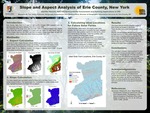
In conjunction with Erie County's Office of GIS Services, research was conducted to map and analyze slope angles and aspects of the entire county. Through this study, we found the areas of steepest slopes in the county. Then, we took a further step to explore possible locations for future solar farms. The parameters used for determining the best locations of solar farms were: (1) a solar farm would be on a south facing slope in terms of slope aspect, and (2) the slope angles are best to be 5% or less. This work was conducted using a 2-meter spatial resolution digital elevation model (DEM) of Erie County, and various software tools in ESRI-ArcGIS, such as Slope, Aspect, and Reclassify. The highest elevation is found in southern Erie County, with flatter land up north. The steepest slopes were found along hills in the southern county as well. It was also found that there are many potential locations for solar farms across the county, with large areas of land being suitable both in the north and south. Future research is needed with more parameters, such as the number of sunny days and precipitation totals, as solar farms are more effective in sunny regions.
Publication Date
2021
Recommended Citation
Hanson, Jennifer, "GIS Analysis of Slope Distributions and Future Solar Energy Farms" (2021). Physical Geography and Sciences. 9.
https://digitalcommons.buffalostate.edu/srcc-sp21-physgeosci/9