


-

Structural and Geochemical Documentation of Metamorphic Rocks from Coastal and Inland Maine
Genna Baldassarre
Genna Baldassarre, Geology
Faculty Mentor(s): Professor Gary Solar, Earth Sciences and Science Education
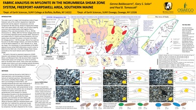
Rocks exposed in southern inland Maine, located in the Freeport area, were formed over 400 million years ago, and then metamorphosed and deformed from about 400 to 280 million years ago. This was within a more than 15 km-wide zone of continental collisional deformation known as the Norumbega shear zone system (NSZS) during the Acadian through Alleghenian Orogenies (mountain building during continent-continent collisions). Evidence of the tectonic plate collisions in question exists at the grain scale, and can be studied and measured through the use of polarized transmitted-light microscopy (petrography) of thin sections. Thin sections were prepared from specimens carefully selected from a suite of rocks collected in the field in the Freeport area. They were then described and measured extensively, with the main focus of the study on mineral composition related to near areas, and characteristic mineral growths resulting from metamorphism unique to this field area. Compared to other similar rocks from surrounding areas, the rocks I have studied from Freeport have a lesser porphyroblast-composed matrix and a more interlocked quartz and twinned plagioclase matrix. Whereas subsequent deformational events may alter the matrix minerals, these inclusion minerals are preserved and reflect the original matrix at time of growth. Mineral data was collected from thin section creation and analysis. Throughout thin sections there is consistent biotite lineation, confirming deformation during metamorphism and the apparent direction of the sample foliations. All of these data are reconciled to form interpretations of the tectonic history as recorded by the rock itself. The data documented shows that the extensive tectonic history within the Norumbega shear zone system was long-lived as new matrix fabrics formed over old ones progressively. -

Does Cell Communication Modulate Volume Changes?
Alexandra Bone
Alexandra Bone, BIO495: Independent Project
Faculty Mentor(s): Professor Derek Beahm, Biology
Cell volume is fundamentally important to normal cell function. Volume changes arise when normal or pathological conditions create an osmotic imbalance across the plasma membrane, resulting in water influx or efflux until the inside of the cell is osmotically matched to the external environment. Knowledge of cell volume regulation has been obtained primarily through studies on isolated single cells. However, most cell types communicate with each other directly through gap junction channels that allow the cells to share small molecules including water, ions, metabolites, and signaling molecules. Gap junctions provide a transport pathway between cells that does not involve the plasma membrane. We are interested in understanding if and how gap junction communication affects the rate and extent of cell volume changes. An important part of the project is to measure volume changes in individual cells within a cell population. Fluorescent stains and confocal microscopy were used to generate 3-dimensional models of cell monolayers before and after exposure to osmotic challenges. Data is presented on the use of nuclear cross-sectional area and cell height as indirect measures of cell volume. We found that cell height changes correlated well with cell shrinking and swelling induced by exposing homogeneous cell populations to hypertonic and hypotonic media, respectively. Additional data will be presented on volume changes of cells in heterogeneous populations before and after the application of gap junction blockers. These data contribute to ongoing efforts to better understand the role of gap junction communication in cell volume dynamics. -

Determining the Source of Toxic Heavy Metals in Closed-System E-Cigarettes
Ashleigh Coggins-Block
Ashleigh Coggins-Block, Forensic Science
Faculty Mentor(s): Professor Jinseok Heo, Chemistry, Professor Noel Leigh, Roswell Park Comprehensive Cancer Center, Dr. Maciej Goniewicz, Roswell Park Comprehensive Cancer Center
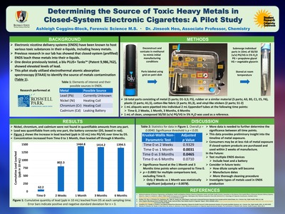
Background: Potential toxicants emitted from electronic nicotine delivery systems (ENDS) include various types of heavy metals, such as lead, nickel, chromium, and cadmium, all of which pose a variety of health risks, including cancer. Previous research has shown these metals do not originate from refill solutions, instead they may be leaching into e-liquids over time from the parts of ENDS devices. Methods: A pre-filled ENDS device from the International Tobacco Control (ITC) 4-country survey was selected to pilot this study based on high levels of lead previously detected in its e-liquid. The device, a Blu Plus cartridge not connected to a battery, was purchased in 2017 from England and was deconstructed into its individual assembly components. Each component was washed and sonicated using methanol, then submerged separately in 10 mL of a blank e-liquid solution. One milliliter samples were taken at time: 0, 2 weeks, 1 month, 3 months, and 6 months and tested for levels of lead, nickel, chromium, and cadmium using atomic absorption spectroscopy. Results: Nickel, chromium, and cadmium were not quantifiable for any timepoint or component. One component, the device's metallic battery connector, was found to be a significant source of lead, which was detected with increasing concentration at each sampling time point. Conclusions: This study has identified a component of ENDS devices that can be a significant source of toxic lead. It also sets the groundwork for more extensive heavy metal contamination studies on a diverse range of ENDS products in the future. -

Antibacterial Oligo-Arylureides
Anna Dano, Gregory O'Brien, and Victoire-Grace Karambizi
Anna Dano, Biology, Gregory O'Brien, Biology, Victoire-Grace Karambizi, Biology
Faculty Mentor(s): Professor Sujit Suwal, Chemistry, Professor Olga S. Novikova, Biology
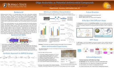
Multidrug-resistant bacteria is an emerging global threat that is demanding worldwide attention. There is an urgent need for the innovation of novel therapeutics to replenish conventional antibiotics regimens. Several host defense Anti-Microbial Peptide (AMP) having immunomodulatory properties are currently developed into an antibacterial agent to overcome this biological obstacle. However, such molecules are cytotoxic, susceptible to undergo enzymatic degradation, and expensive. Likewise, several AMP-biomimetics are used in clinical trials to combat potential epidemics due to the possible evolution of new bacterial strains. In our lab, we recently developed a new class arylureido peptoids (ArU) through solid-phase synthesis. We demonstrated that a functionally diverse ArU library can be generated by coupling commercially available primary amines and arylisocyanate using split & pool synthetic approach. We are currently testing the antibacterial properties of some of the ArU molecules against different strains of microbials - Escherichia coli and Staphylococcus aureus. We explored the size of the ArU-backbone by adding methylamine as the side chain of the oligomers. After successful optimization of the oligomer size, we diversified the sidechain, measured MIC, CFU and able to identify our hit molecule. We found MIC value of the hit molecule is comparable to ampicillin treatment, at least against E. Coli. Currently, we are pursuing in-vitro cytotoxicity assay of the hit molecule against a human cell. -

3D Elevation Profile Analysis for Erie County Park Trails
Tev'ye Davis
Tev'ye Davis, GEG418: Remote Sensing
Faculty Mentor(s): Professor Tao Tang, Geography and Planning, Director Lisa Matthies-Wiza, Erie County Office of Geographic Information Services
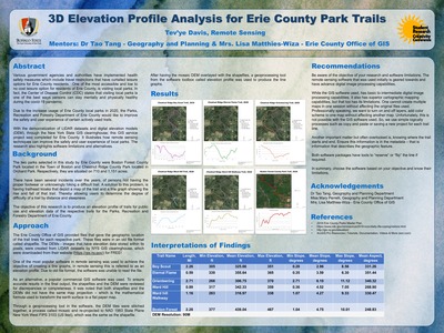
Various government agencies and authorities have implemented health safety measures which include travel restrictions that have curtailed leisure options for Erie county residents. One of the most accessible and low- to no-cost leisure options Erie County residents is visiting local parks. In fact, the Centers for Disease Control and Prevention (CDC) states that visiting local parks is one of the best ways people can stay mentally and physical healthy during the Covid-19 pandemic. Due to the increased usage of Erie County local parks in 2020, the Parks, Recreation and Forestry Department would like to improve the safety and user experience of certain actively used trails. With the democratization of LIDAR datasets and digital elevation models through the New York State GIS clearinghouse, this GIS service project, completed for Erie County, illustrates how local parks safety and user experiences can be improved. We also highlight software limitations and alternatives. -

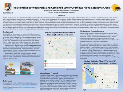
Relationship Between Parks and Combined Sewer Overflows Along Cazenovia Creek
Caitlin Ernst
Caitlin Ernst, GES460: Environmental Field Methods
Faculty Mentor(s): Professor Elisa Bergslien, Earth Sciences and Science Education
Buffalo, like many older cities, has a Combined Sewer system, where the rain running into drains along the streets enters shared pipes with the discharge from the residential and industrial sewage system. During heavy rain events, when large amounts of rainwater enter the pipes, the system can be overwhelmed and a mixture of rain and untreated sewage can be discharged directly into nearby bodies of water through Combined Sewer Overflow (CSO) outfalls. According to the Buffalo Sewer Authority (BSA), there are several CSO outfalls along Cazenovia Creek that let out near parks or recreation areas. This could be potentially hazardous, especially for children or pets playing. For this project, water, soil and sediment samples will be taken from several locations along the creek. Samples will be taken during normal periods as well as after rain/high flow events. Samples will be taken downstream from overflow points at constant intervals, and at points by public areas. Vegetation and wildlife will be observed, and samples will also be taken near area with potentially dying or lacking in vegetation. As many historical readings, reports or samples that may have been taken along the creek as can be located will also be incorporated in this project. In addition, this information will be compared, wherever possible, to the historic Redlining Maps created by agents of the federal government's Home Owners' Loan Corporation between 1935 and 1940 to see if there is any relationship between overflows still not fixed, the amount of discharge and the areas where they are found. -

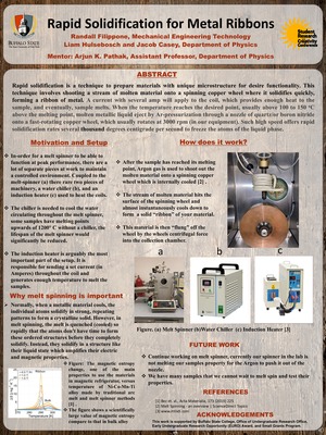
Rapid Solidification for Metal Ribbons
Randall Filippone, Liam Hulsebosch, and Jacob Casey
Randall S. Filippone, Electrical Engineering Technology, Liam Hulsebosch, Physics, Jacob Casey, Physics
Faculty Mentor(s): Professor Arjun Pathak, Physics
Rapid solidification is a technique to prepare materials with unique microstructure for desire functionality. This technique involves shooting a stream of molten material onto a spinning copper wheel where it solidifies quickly to form a ribbon of metal. In the typical melt-spinning process, about 5 to 10 g of the alloy is placed inside a quartz or sometimes boron nitride crucible depending on the materials melting temperature, and then the crucible is inserted into the circular induction coil. The current with several amps will apply to the coil, which provides enough heat to the sample, and eventually, it melts. To maximize the melting process, samples temperature should rise several degrees above the melting temperature of the alloy of which ribbons to be prepared. When the temperature reaches the desired point, usually above 100 to 150 degrees C above the melting point, molten metallic liquid eject by Air-pressurization through a fine nozzle of quartz/or boron nitride onto a fast rotating copper wheel, which usually rotates at 3000 rpm (in our equipment). Such high speed offers rapid solidification rates several thousand degrees centigrade per second to freeze the atoms of the liquid phase. We are currently installing melt spinner equipment at the physics department and planning to get ready to synthesize metallic samples in near future. Here we present the installation process of the melt spinner, optimization, and importance of this technique for material science research. -
 Compounds by Randall S. Filippone")
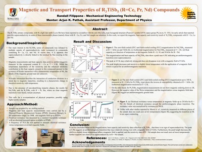
Magnetic and Transport Properties of R3TiSb5 (R=Ce;Pr;Nd) Compounds
Randall S. Filippone
Randall S. Filippone, Electrical Engineering Technology
Faculty Mentor(s): Professor Arjun K. Pathak, Physics
Rare-earth (R) intermetallics show a wealth of interesting fundamental physics due to localized 4f electrons. Importantly, the physical behaviors of these compounds can be tailored by controlling either or both chemistry and structure, hence they remain an intriguing subject for materials science and condensed matter physics communities. Here we present magnetic and transport properties of ternary rare-earth transition metal antimonides with the stoichiometry R3TiSb5 (R=Ce, Nd, Pr). The compounds crystallize in the anti-Hf5CuSn3 -type hexagonal structure, space-group P63/mcm (hP18). Our magnetic measurements show that the compounds with R=Ce, Nd undergo antiferromagnetic transition below 5K. However, the compound with R=Pr does not show magnetic ordering down to 1.5K. The resistivity for R=Nd was also measured from 2 to 300K at magnetic field up to 5 Tesla. The resistivity shows metallic behavior with a transition around 5K for R=Nd, which is consistent with the magnetic measurement. This work has been carried out in collaboration between Buffalo State College, the University at Genova, Italy, and Institut Laue-Langevin, Grenoble, France. -
 in Tributary Streams of Eastern Lake Erie by Kyle Glenn")
Invasive Round Goby (Neogobius melanostomus) in Tributary Streams of Eastern Lake Erie
Kyle Glenn
Kyle Glenn, Biology
Faculty Mentor(s): Professor Christopher Pennuto, Biology
The invasive Round Goby (Neogobius melanostomus) alters macroinvertebrate communities in newly colonized environments throughout the Great Lakes region. I revisited four streams which were examined for Round Goby impacts in 2005 by a former graduate student at Buffalo State College, using the same collection techniques at the same time of year. Gobies appear to have expanded their range since the 2005 assessment. Two of the four streams sampled supported Round Goby populations both in 2005 and 2020, whereas one stream which did not have gobies in 2005 currently has a population. Both streams harboring Round Gobies had lower total invertebrate abundance, taxa richness, and taxa diversity than was reported in 2005. A comparison of current streams with and without gobies did not show any consistent differences in the three metrics examined. Collectively, these results indicate Round Goby continue to expand their distribution and streams with gobies present over the last 15 years appear more impacted by this invasive fish. -

Synthesis of Fe4Nb2O9 and Mn4Nb2O9 Oxides
Michael Grey
Michael Grey, PHY495: Special Project
Faculty Mentor(s): Professor Ram Rai, Physics
This research project was focused on synthesis of Mn4Nb2O9 and Fe4Nb2O9 oxides, which were successfully synthesized via conventional solid-state reaction. The important step in synthesis of these compounds was to use the argon gas environment during the sintering process. In this presentation, we report detail synthesis processes and characterizations of these two compounds. The x-ray diffraction characterization revealed a single-phase compound with a purity of >99%. The magnetization versus temperature data show an antiferromagnetic transition temperature of ï¾93 K and ï¾110 K for Fe4Nb2O9 and Mn4Nb2O9, respectively. We used one-inch diameter Mn4Nb2O9 target for Magnetron Sputtering to deposit Mn4Nb2O9 thin films on (001) Al2O3 (sapphire) and (001) LiNbO3 single crystal substrates. The x-ray diffraction patterns of Mn4Nb2O9 thin films on LiNbO3 show a preferentially c-plane oriented thin film. We will also present the optical properties and magnetization data of Mn4Nb2O9 thin films. -

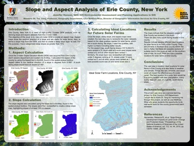
GIS Analysis of Slope Distributions and Future Solar Energy Farms
Jennifer Hanson
Jennifer Hanson, GEG428: Environmental Assessment and Planning Applications in GIS
Faculty Mentor(s): Professor Tao Tang, Geography and Planning, Professor Lisa Matthies-Wiza, Erie County Office of Geographic Information Services
In conjunction with Erie County's Office of GIS Services, research was conducted to map and analyze slope angles and aspects of the entire county. Through this study, we found the areas of steepest slopes in the county. Then, we took a further step to explore possible locations for future solar farms. The parameters used for determining the best locations of solar farms were: (1) a solar farm would be on a south facing slope in terms of slope aspect, and (2) the slope angles are best to be 5% or less. This work was conducted using a 2-meter spatial resolution digital elevation model (DEM) of Erie County, and various software tools in ESRI-ArcGIS, such as Slope, Aspect, and Reclassify. The highest elevation is found in southern Erie County, with flatter land up north. The steepest slopes were found along hills in the southern county as well. It was also found that there are many potential locations for solar farms across the county, with large areas of land being suitable both in the north and south. Future research is needed with more parameters, such as the number of sunny days and precipitation totals, as solar farms are more effective in sunny regions. -

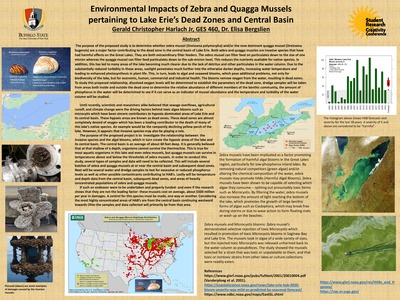
Environmental Impacts of Zebra and Quagga Mussels in Lake Erie Central Basin
Gerald Harlach
Gerald Harlach, GES472: Geology Senior Seminar
Faculty Mentor(s): Professor Elisa Bergslien, Earth Sciences and Science Education
The purpose of this study is to determine whether zebra mussel (Dreissena polymorpha) and/or the now dominant quagga mussel (Dreissena bugensis) are a major factor contributing to the dead zone in the central basin of Lake Erie. Both zebra and quagga muscles are invasive species that have had harmful effects on the Great Lakes. They are both extraordinary filter feeders. The zebra mussel can filter feed on particulates down to the size of one micron whereas the quagga mussel can filter feed particulates down to the sub-micron level. This reduces the nutrients available for native species. In addition, this has led to many areas of the lake becoming much clearer due to the lack of detritus and other particulates in the water column. Due to the substantially reduced turbidity in these areas, sunlight penetrates much further into the otherwise darker depths, increasing water temperature and leading to enhanced photosynthesis in plant life. This, in turn, leads to algal and seaweed blooms, which pose additional problems, not only for biodiversity of the lake, but for economic, human, commercial and industrial health. The blooms remove oxygen from the water, resulting in dead zones. To study this proposed relationship, dissolved oxygen levels will be determined to establish the parameters of the dead zone, dredge samples will be taken from areas both inside and outside the dead zone to determine the relative abundance of different members of the benthic community, the amount of phosphorus in the water will be determined to see if it can serve as an indicator of mussel abundance and the temperature and turbidity of the water column will be studied. -

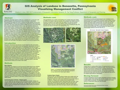
GIS Analysis of Land Use in Benezette; Pennsylvania: Visualizing Management Conflict
Shakira Jinez
Shakira Jinez, Biology
Faculty Mentor(s): Professor Tao Tang, Geography and Planning
Geographic Information Systems (GIS) are a valuable tool in conservation both active and passive. The Pennsylvania Game Commission of Benezette, Pennsylvania has utilized GIS tools to maintain and keep detailed records of the unique landscape in which elk and residents live in abnormally close proximity to each other. The unique relationship between wildlife and locals has led Benezette to be a popular tourist destination which, in turn, has increased instances of human-animal conflict. Increased concern within the game commission for the safety of both residents and tourists has opened a need for further visualization of the game lands which, at times, overlaps residential and tourist areas. In this simulation, various layers of GIS data were obtained via the Pennsylvania Spatial Data Access (PSDA) and manipulated with ERDAS Imagine and ArcGIS to create a categorized map of land use within the Benezette area. The map allows us to visualize the overlap between private residencies, tourism hot spots, and the game land. The results highlight areas of interest in which the Pennsylvania Game Commission may revitalize management efforts with the objective of minimizing human-animal conflict. Tourist attractions on private property identified via the simulation open opportunities between land managers and owners to combat concerns from both sides of the spectrum between community and government. -

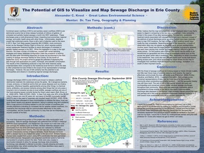
The Potential of GIS to Visualize and Map Sewage Discharge Reports
Alexander Krest
Alexander Krest, GEG525: Fundamentals of GIS
Faculty Mentor(s): Professor Tao Tang, Geography and Planning
Combined sewer overflows (CSOs) and sanitary sewer overflows (SSOs) are detrimental events that at times release hundreds of millions of gallons of untreated and partially treated sewage per month into WNY waterways. These discharges pose a multi-dimensional threat, impacting local economies, regional ecology, and public health, among other things. Unfortunately, despite a couple highly publicized events, there is still a lack of attention paid to this issue. In 2013, New York State passed Assembly Bill A10585A, more commonly known as the Sewage Pollution Right to Know Act, which requires publicly owned wastewater treatment facilities to report discharges of untreated or partially treated sewage to the DEC. While this legislation is a step in the right direction, the sheer number of incidences, coupled with varied reporting strategies and messy database configuration make the prospects of working with this data quite intimidating, especially for those not accustomed to the field. Looking at sewage discharge reports for Erie County for the month of September 2019, this project aimed to gauge the potential of displaying this data through GIS applications for public, municipal, and scientific consumption. The results of this undertaking produced a map that--while relatively easily understandable when compared to the traditional Excel format in which the data is often presented--was limited in the scope of true representation of sewage discharges. However, the use of GIS certainly has the potential to aid municipalities and citizens in visualizing regional sewage discharges. -

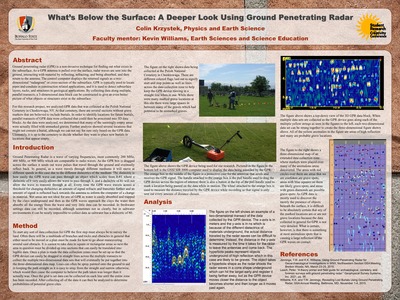
What's Below the Surface: A Deeper Look Using Ground Penetrating Radar
Colin Krzystek
Colin Krzystek, HON400: All College Honors Colloquium
Faculty Mentor(s): Professor Kevin Williams, Earth Sciences and Science Education
Ground penetrating radar (GPR) is a non-invasive technique for finding out what exists in the subsurface. As a GPR antenna is pulled over the surface, radar waves are sent into the ground, interacting with material by reflecting, refracting, and being absorbed, and then return to the antenna. The control computer displays the returned signals as a two-dimensional “radargram” or cross-section of the subsurface. GPR is typically used to locate pipes and conduits in construction related applications, and it is used to detect subsurface layers, rocks, and structures in geological applications. By collecting data along multiple, parallel transects, a 3-dimensional data block can be constructed to give an even better picture of what objects or structures exist in the subsurface. For this research project, we analyzed GPR data that was collected at the Holy Mother of the Rosary Historic Cemetery in Cheektowaga, NY. At that cemetery, there are several sections without grave markers that are believed to include burials. In order to identify locations for future burials, parallel transects of GPR data were collected that could then be processed into 3D data blocks. As the data were analyzed, we determined that many of the seemingly empty areas were actually filled with unmarked graves. Further analysis showed several locations that might not contain a burial, although we cannot say for sure only based on the GPR data. Ultimately, it is up to the cemetery to decide whether they want to place new burials in locations that appear empty. -

A Study of Cyclones in Mozambique Applying Remote Sensing
Elizabeth Mahoney
Elizabeth Mahoney, GEG418: Remote Sensing
Faculty Mentor(s): Professor Tao Tang, Geography and Planning
Mozambique is a poor and rapid economic developing nation on the Eastern Coast of Africa. In the spring of 2019, two massive tropical cyclones made landfall on the coast through the Mozambique Channel. The resulting devastation had catastrophic effects including massive loss of life, infrastructure, and crops, among other humanitarian crises. Using Landsat 8 satellite images obtained from US NASA that were taken before and after the two storms, I processed multiple imagery maps using ERDAS imagine software to classify the changes of land use before and after the cyclones and to access the disaster and damage to the country. Using the tools and skills in Remote Sensing, my aim is to visually represent the gravity of the crisis that affected and continues to affect Mozambique. Understanding the impacts of these storms on land use, agriculture, GDP, the loss of human life and many other factors including the HDI (United Nations Human Development Index), we can learn what outcomes can be expected as climate change causes more storms of this nature with increasing strength and frequencies. I hope that we can improve United Nations disaster relief and humanitarian aid handling and enhance direct foreign investments through this study. -

Magnetic, Thermodynamic, and Electrical Transport Properties of Al-Fe-B Based Intermetallic Compounds
Devanshi Malaviya
Devanshi Malaviya, Computer Information Systems
Faculty Mentor(s): Professor Arjun Pathak, Physics
Transition metal borides attracted considerable attention to the scientific community due to its potential applications, including a permanent magnet and cooling devices. AlFe2B2 is one such material that was initially reported by Jeitschko et al. (Acta Crystallogr., Sect. B: Struct. Sci, 25 (1969) 163). Recently, a large magnetocaloric effect near room temperature (Tan et al. JACS 135 (2013) 9553) was reported for the material. The crystal structure of AlFe2B2 based compounds adopts orthorhombic (space group Cmmm) with alternating Al monolayers and Fe2B2 slabs along the long b axis. Here we present the detailed study of the effect of substitution Fe by other 3d elements and B by p-block elements on magnetic, specific heat, and electrical transport properties of AlFe2B2 compound. We observed anomalous electrical transport behavior above and below the ferromagnetic to paramagnetic phase transition and found that transition temperature can be controlled by substitution. -

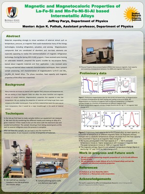
Magnetic and magnetocaloric properties of Mn1-xFexNiSi1-yAly intermetallic alloys
Jeffrey Paryz
Jeffrey Paryz, Physics
Faculty Mentor(s): Professor Arjun Pathak, Physics
Materials responding strongly to minor variations of external stimuli such as temperature, pressure, or magnetic field could revolutionize many of the energy technologies, including refrigeration, actuation, and sensing. Magnetocaloric compounds that are constituted of abundant and non-toxic elements are especially appealing to realize the commercialization of magnetic refrigeration technology. During the EURO program, I was involved in synthesis techniques for bulk magnetocaloric materials, focusing on synthesis and obtaining training for materials' characterization with different techniques. We focused on magnetocaloric materials that have phase transitions around room temperature. In this presentation, I discuss synthesis techniques, materials' properties optimization, and characterization. As an example, I present the phase transition, magnetic and magnetocaloric properties of the Mn1-xFexNiSi1-yAly compound. -

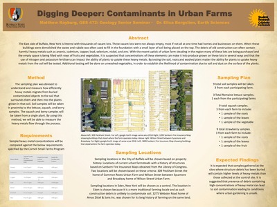
Digging Deeper: Contaminants in Urban Farms
Matthew Rayburg
Matthew Rayburg, GES460: Environmental Field Methods
Faculty Mentor(s): Professor Elisa Bergslien, Earth Sciences and Science Education
The East side of Buffalo, New York is littered with thousands of vacant lots. These vacant lots were not always empty, most if not all at one time had homes and businesses on them. When these were abandoned, buildings were demolished with the waste and rubble often used to fill in the foundation with a small layer of soil being placed on the top. The debris of old construction can often contain harmful heavy metals such as arsenic, cadmium, chromium, lead, mercury, nickel, and zinc. With the recent uptick of urban farm-steading in the region, many of these lots are being purchased and the empty space is being filled with rows of fruits and vegetables. It is likely that some concentrations of these hidden toxic elements can make it into produce grown on these lots via different pathways and that the use of nitrogen and potassium fertilizers can impact the ability of plants to uptake these heavy metals. Several test locations were selected based on their historic and current use. Sites with known debris and sites that have no history of construction are compared. Soil, potatoes, carrots, beans and lettuce were collected and dried. The collected samples were analyzed using microXRF in order to determine how the load in the plants compares to the levels of the heavy metals in the soil, and to assess the safety of plants grown by the urban farms and determine if any risks are present to those who consume them. -

Central Park: Harmful Algal Blooms
Nathalie Rivas
Nathalie Rivas, GES460: Environmental Field Methods
Faculty Mentor(s): Professor Elisa Bergslien, Earth Sciences and Science Education
New York City is home to one of the best known parks in the country, Central Park, with its massive size ranging from the upper west to the lower east side of Manhattan. Central Park is home to numerous habitats, bodies of water, and species. Despite its glory, Central Park is also home to plants that are damaging to the environment. Harmful Algal Blooms (HABs) occur when colonies of algae grow out of control due to changes in water quality. The water becomes overfed by certain nutrients, primarily nitrogen and phosphorus, due to the human activities. They can create dramatic changes such as depletion of oxygen levels, reduction in the amount of sunlight an ecosystem receives, and can even cause negative health effects on humans. In recent years, HABs have also been linked to the death of many pets who drank water in the park. In this study, an analysis of the water quality of two bodies of water in Central Park will be conducted to understand why HABs are suddenly increasing in the environment: the Reservoir and Turtle Pond. The Reservoir used to be a water supply for NYC residents in the 1860s connecting to the Croton Aqueduct, while Turtle Pond resides on an area formerly part of the Aqueduct. Since both bodies of water are treated differently today despite their similar backgrounds, a comparison of their water quality can help isolate what factors may be contributing to an increase in the blooms. Levels of nitrogen, phosphorus, and dissolved oxygen were sampled in both the Reservoir and the Turtle Pond, and their usage and treatment examined to see what causes the blooms to appear, such as the amount of fertilizer used to the surrounding grass. The importance of this study is to understand why HABs are rapidly occurring in Central Park, in order to stop continued negative effects on the environment and human health. -

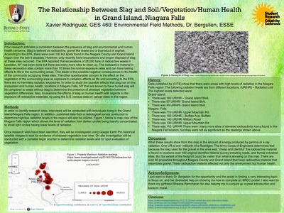
Relationship Between Slag and Soil/Vegetation/Human Health in Grand Island; Niagara Falls
Xavier Rodriguez
Xavier Rodriguez, GES460/529: Environmental Field Methods
Faculty Mentor(s): Professor Elisa Bergslien, Earth Sciences and Science Education
Prior research indicates a correlation between the presence of slag and environmental and human health concerns. Slag is defined as radioactive, gravel-like waste and a byproduct of asphalt. According to the EPA, there were over 100 hot spots found in the Niagara County and Grand Island region over the last four decades. However, only recently have excavations and proper disposal of slag at these sites occurred. The EPA reported that excavations of 28,000 tons of radioactive waste in Lewiston, New York have been done, but there are many more sites to clean up. The radioactive material in these excavation sites contain more than 70 times the normal exposure rates and can have lasting effects to life in the surrounding areas. This leads to possible negative consequences to the health of the communities occupying these sites. The other concern is the effect on the vegetation in the surrounding area as exposure to radiation effects all life and according to the EPA, there are no harmless radiation exposures. In order to study the possible effects that slag has on the ecosystem and human health, locations of known disposal sites in Niagara Falls will be evaluated for stressed vegetation/extreme vegetation differences in the soil containing slag. To examine the effects of slag on human health with regards to the exposure of radioactive materials, U.S. census and Department of Health data on cancer rates in this region be mapped. -

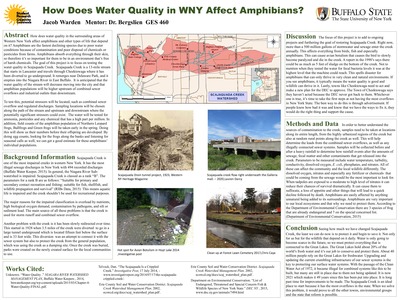
How Does Water Quality in Western New York Affect Amphibians?
Jacob Warden
Jacob Warden, GES460/472/529: Environmental Field Methods
Faculty Mentor(s): Professor Elisa Bergslien, Earth Sciences and Science Education
How does water quality in the surrounding areas of Western New York affect amphibians and other types of life that depend on it? Amphibians are the fastest declining species, due to poor water conditions because of contamination and poor disposal of chemicals or pesticides from farms. Amphibians absorb everything through their skin, so this is why it is important for them to be in an environment free of harsh chemicals. The goal of this project is to focus on testing the water quality in Scajaquada Creek. Scajaquada Creek is a 13-mile stream that starts in Lancaster and travels through Cheektowaga where it has been diverted to flow underground. It remerges near Delaware Park and it empties into the Niagara River in East Buffalo. It is anticipated that the water quality of the stream will decrease moving into the city and that amphibian populations will be higher upstream of combined sewer overflows and industrial outlets than downstream. To test this, potential stressors will be located, such as combined sewer overflow and regulated discharges. Sampling locations will be chosen along the path of the stream and upstream and downstream where the potentially significant stressors could exist. The water will be tested for ammonia, pesticides and any chemical that has a high part per million. In addition, field counts of the amphibian population of Northern Leopard frogs, Bullfrogs and Green frogs will be taken early in the spring. Doing this will show us their numbers before their offspring are developed. By doing egg counts, looking for the frogs along the banks and listening for seasonal calls as well, we can get a good estimate for these amphibians' individual populations.
